Marine Survey Technology
Applications of Side-Scan Sonar: From Seafloor Mapping to Shipwreck Discovery
Of all the instruments used to picture the seafloor, side-scan sonar remains the most versatile—not because it is the most technically advanced, but because it produces an instantly readable image. When a hard object protrudes from a muddy seabed, or when a pipeline that should be buried turns out to be exposed along dozens of meters, side-scan sonar is typically the first instrument to reveal it.
How Side-Scan Sonar Works
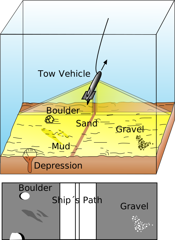
The instrument emits conical or fan-shaped acoustic pulses toward the seafloor, perpendicular to the direction of travel of the sensor—whether towed behind a vessel (a "towfish") or hull-mounted. The intensity of the acoustic returns from the seabed is recorded as a series of cross-track slices, which, stitched together along the direction of motion, form an image of the seafloor within a given swath width.
Hard objects protruding from the seabed return strong echoes and appear dark on the image, while soft areas such as mud and sand return weak echoes and appear light—a contrast that makes side-scan sonograms so intuitive to read, even for eyes without formal technical training.
Operating frequencies typically range from 100 to 500 kHz, with variations spanning roughly 50 kHz (for wide-swath coverage) up to nearly 1 MHz (for maximum image detail). The underlying trade-off is consistent: higher frequencies yield sharper resolution but shorter range, while lower frequencies extend swath coverage at the cost of fine detail. Beamwidth compounds this trade-off—a narrow beam sharpens the image but reduces swath width.
The towfish is typically towed at an altitude of roughly 10–20% of the sonar's range above the seabed, staying close enough to the bottom to allow higher frequencies to be used. One fundamental limitation of the technology is the nadir gap—a strip of missing data directly beneath the towfish's track, since the pulse geometry does not directly insonify the area straight below it.
A Brief History: From Classified Military Project to Commercial Tool
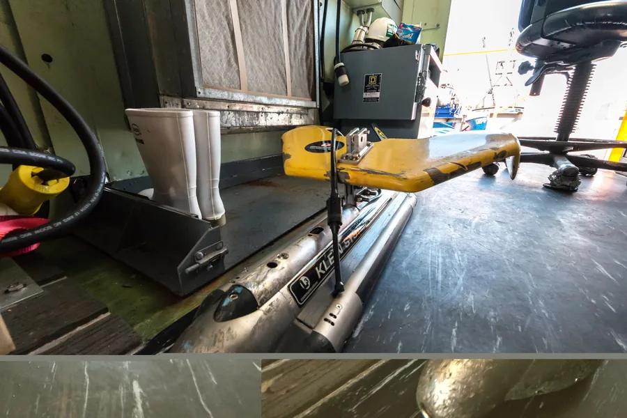
Side-scan sonar began as a classified U.S. Navy project in the mid-1950s. Once the original patent was declassified in 1958, the technology started migrating toward commercial use. The turning point came when Martin Klein, an MIT-trained engineer, led a team at Edgerton, Germeshausen & Grier in developing a towed, dual-channel side-scan sonar system between 1963 and 1966. In 1967, Klein introduced the system at a Marine Technology Society convention in San Diego—before that, side-scan sonar had existed only as expensive classified systems or one-off research prototypes at select institutions.
Klein went on to found Klein Associates (now Klein Marine Systems) in 1968, continuing to develop the first commercial high-frequency (500 kHz) systems, the first dual-frequency side-scan sonars, and the first combined side-scan and sub-bottom profiling sonar.
Core Applications in the Field
Geological mapping and navigational safety
Side-scan sonar is particularly valuable when surveying hazards to shipping lanes and conducting large-scale geological mapping of the seabed. Its ability to image extensive areas quickly—regardless of water clarity—makes it a first-choice tool for efficient object detection and bathymetric feature identification.
Subsea pipeline and cable inspection
Because it can directly provide acoustic imaging of seabed morphology, side-scan sonar is widely applied in submarine engineering surveys—particularly pipeline inspection. It is used to investigate the condition of pipelines and cables on the seafloor, including measuring the height of pipe segments exposed above the seabed, the height of suspended free spans, and the extent of surrounding scour.
UXO detection for offshore renewable energy projects
Marine UXO (unexploded ordnance) surveys typically combine magnetometers, gradiometers, sub-bottom profilers, and side-scan sonar to scan for anomalies at and below the seafloor. As an indication of modern capability, systems such as the Klein 5900 can detect objects as small as a golf ball at survey speeds up to 12 knots—a combination of speed and resolution that proves critical for offshore wind farm projects, where every stage of a project's lifecycle, from initial site assessment through ongoing foundation inspection, depends on high-quality seafloor imagery.
Maritime archaeology and shipwreck discovery
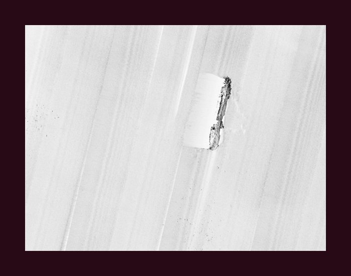
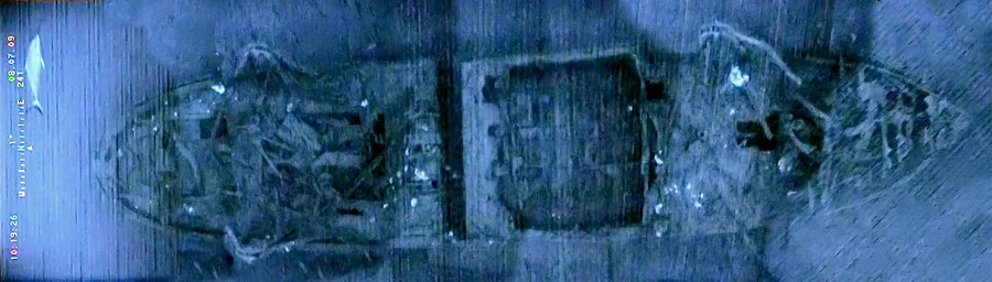
The most iconic case in the history of side-scan sonar applications is the discovery of RMS Titanic on July 1, 1985. The French research vessel Le Suroit spent ten days towing a state-of-the-art side-scan sonar system, capable of sweeping 3,000-foot passes of the ocean floor, before a joint team from the Woods Hole Deep Submergence Lab (led by Dr. Robert Ballard) and France's IFREMER (led by Jean Jarry) successfully localized the wreck. In 2012, a follow-up expedition used autonomous robots equipped with side-scan sonar to produce the first complete map of the wreck site—including the revelation that the stern rotated like a helicopter blade as it sank, rather than simply plummeting straight down.
Standards and Coverage Limitations
Under the IHO S-44 framework (the International Hydrographic Organization's Standards for Hydrographic Surveys), Special Order surveys require closely spaced survey lines using side-scan sonar, multi-transducer arrays, or multibeam echosounders to achieve "100% bottom search". In practice, however, complete seafloor ensonification is never fully attainable, owing to inherent acoustic shadows and the nadir gap built into the technology's operating geometry.
Beyond navigational safety, the S-44 standard has also been adapted to support oil and gas, renewable energy, dredging, geophysics, and geotechnical applications—a scope that reflects just how far side-scan sonar's use has expanded beyond its origins as a military tool.
Conclusion
From a classified U.S. Navy project in the 1950s to the backbone of modern offshore wind farm UXO surveys, side-scan sonar has proven to be one of the most enduring instruments in the history of marine geophysics—not because it was never superseded, but because it has continually been refined. Its ability to produce an image that a human eye can instantly interpret remains an advantage no other technology has matched, making it the first instrument called upon whenever the question is simple: what is actually down there?
References
- NOAA Ocean Exploration — Side-Scan Sonar
- Wikipedia — Side-scan sonar
- Unique Group — Side Scan Sonar: What It Is, How It Works and Offshore Uses
- Wikipedia — Martin Klein (engineer); Marine Technology News — Klein's Side Scan Sonar, Then and Now
- Klein Marine Systems — Offshore Renewables & UXO
- ScienceDirect Topics — Side Scan Sonar
- International Hydrographic Organization — IHO S-44 Standards for Hydrographic Surveys; IHR — International hydrographic survey standards
- TIME.com — Titanic Wreck Site Mapped for First Time Using Sonar Imaging; Titanic-Titanic.com — Discovery Of Titanic